The flag of Argentina...pretty! Now you would think this flag would be unique enough that I might remember it. Sadly, my performance at trivia doesn't follow that concept!
We spent the morning cruising through several channels on our way to Ushuaia with views of lovely snow-capped mountains.
You can see where the glaciers used to be, where the trees have not grown in and the ice has melted.
On this mountain you could still see the bluish ice of the glacier.
It was so calm and so peaceful…
More evidence of the receding glaciers…
Imagine what these mountains used to look like. The areas at the top that are bare were once capped in snow and ice.
Stunning scenery…
And here we are again in Ushuaia. It was originally a mission town, then an Argentine naval base and then a convict settlement. Its claim is being the southernmost city on earth and it’s the main jump-off point for tourists and international scientists heading for Antarctica. It is literally the end of the road as the Pan-American Highway ends in Tierra del Fuego Park.
It was a beautiful sunny day. Much warmer than anyone expected…
The usual hubbub of activity on the pier…
The last time we were here we did the cruise of the Beagle Channel, which was wonderful for seeing lots of seals and birds. Today we decided to take the bus tour to the National Park, literally to the end of the earth. It will be Jim’s first outing in 8 days and I don’t think we could have picked anything less taxing.
And we’re off to see the sights…
It’s very hilly…
With lots of one way streets…
This house is typical of the original early designs with tin siding…
Ushuaia has grown rapidly in recent years due to federal development programs and the mishmash of housing is indicative of rapid growth without a plan.
We soon left the town and were on a dirt road, where this flowing brook...
Turned into a flowing river…
An equestrian school…
And a 9 hole golf course…
Here we are entering Tierra del Fuego National Park. It is located in southwest Argentina against the border of Chile and protects 63,000 hectares of the southern tip of the Andes Mountains. It was first occupied by man more than 10,000 years ago! These tribal people lived in harmony with the environment, until the arrival of the Europeans in the late 1800s. Many died of disease, but many were also hunted down by explorers and poisoned by colonists and sealers to allow easy access to sea lion colonies.
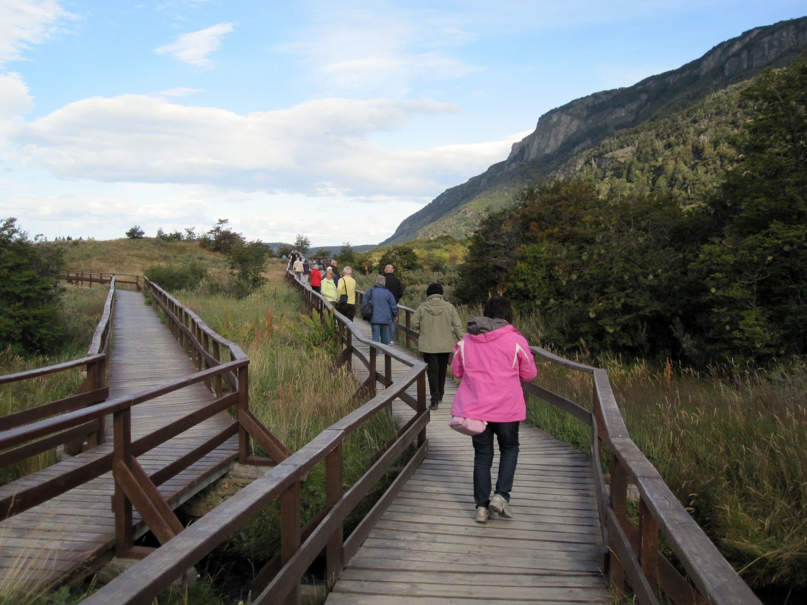
Today it is very popular with hikers from all over the world. The temperature year round hardly changes. In the winter it will be around 0°C and in the summer around 10°C. It was a balmy day when were there...it probably hit around 15°!
Our first stop was the beautiful Bahia Ensenada which has views of Beagle Channel and beyond.
Ta da! You cannot go any further south than this before you hit the Antarctic. Jim is out and about!
Might be a bit windy sometimes!
The very busy post office…you can bring your passport in and have it stamped with “Fin del Mundo,” but we settled for buying a couple of postcards.
Our tour guide, Domingo…he was a great guide with extensive knowledge of the flora and fauna.
The roads we travelled all afternoon. It was quite dusty which probably didn't do Jim's breathing any good.
Beavers were brought in from Canada in 1947 to boost the species population which is very sparse. They also brought in rabbits from Europe. The ecosystem was not prepared for these transplanted animals which have caused serious alterations to the landscape and the native flora. Don’t mess with nature! The work of the beavers…
The many peat bogs are signs of earlier glacial lakes. The peat keeps building upon itself until eventually it surfaces.
A backpackers' hostel…
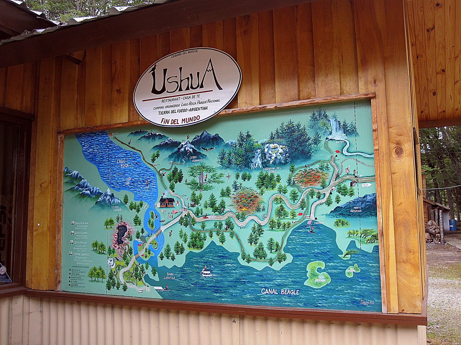
Our next stop was Lake Roca, which is supposed to be great for fishing. We got out for a short walk around the lake.
Domingo explained how these trees decompose from the inside out, so when they eventually fall, they are quickly absorbed into the earth.
Another backpackers' stop…
Jim looking quite perky considering it’s his first outing in more than a week. Or maybe it’s because I said “Smile!”
Lake Roca on the left and all the hikers’ trails…
Now that’s a huge beer!
You can see why it’s a backpackers’ mecca…
Verde (Green) Lagoon…there was also Negra (Black) Lagoon and a few others. It did look greener in person!
A picturesque spot for camping…
Our last stop of the day was at Bahia Lapataia which is the end of the road.
You can't go any further south...
Lots of tourists today…
It was beautiful, but it made me think of our trip across Canada where we saw scenery that matched this. Love Canada!
It must be a totally different experience when there aren’t hordes of buses and taxis touring cruise people around.
The spectacular Andes…
And with that beautiful view, we headed back to town. These houses were the result of a campaign to plan subdivisions rather than the willy nilly mess from before.
The Star Princess against the backdrop of the Five Brothers Mountain. Domingo said that just as the Eiffel Tower is the trademark of Paris, the Five Brothers is the trademark of Argentina. Who knew?
The marina…
I guess this ship isn’t going anywhere…
Jim survived his excursion (yay!) and we now have a sea day before arriving in Stanley, Falkland Islands.
A bunny from Gina…it seemed cruel to eat his eyes, but when a girl needs chocolate...heh, heh!